 |
|
|
|
|
|
|
|
|
|
|
|
|
|
|
|
|
|
|
|
|
|
|
|
|
|
|
|
|
|
|
|
|
|
View from the tower in the 1990's
|
|
|
|
 |
 |
|
|
|
|
Compare these pictures with the view in the 1960's |
|
|
|
|
|
|
|
 |
|
|
|
|
|
|
|
|
|
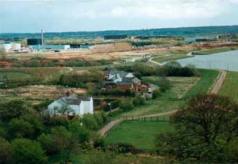
This photo shows the view looking south in 1990. The redway next to the lake is clearly visible and in the distance you can see the earthworks which mark the construction of the new grid road, Tongwell St. The Cotton Valley water treatment works is clearly visible beyond that. |
|
|
|
|
|
|
 |
|
|
|
|
|
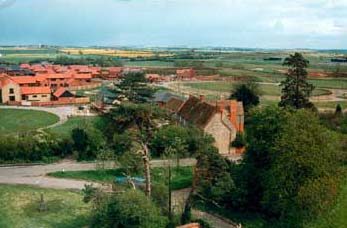
This is the view looking east. The large building in the foreground is Brooke Farm. Beyond that can be seen the new developments in Smabridge Walk and Aldrich Drive |
|
|
|
|
|
|
|
|
|
|
|
|
|
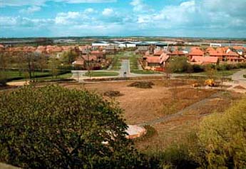
Looking north. Millington Gate can be seen straight ahead. The line of the old road to Newport Pagnell is still marked by Thursby Close on the right but it's no longer a through road. In the distance can be seen the industrial units on Tongwell. The earthworks in the foreground are the preparations for the new village green on an area which had grown wheat for generations. |
|
|
|
 |
|
|
|
|
Photographs by Mark Strutton |
|
|
|
Click to find out about pineapple chunks! |
|
|