Millennium Tour


Aerial view of Willen
Millennium Tour |
||||||||||||
|
||||||||||||
|
|
|
||||||||||
Aerial view of Willen |
||||||||||||
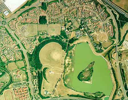
| This aerial photograph shows the Willen area of Milton Keynes as it was in 1996. The 'h' shaped road formation of the old village is still clearly visible around the church, although there is no trace of the medieval ridge and furrow patterns seen in the aerial photo of the 1960s. The landscape has been transformed by the new developments. | ||||||||||||
|
||||||||||||
| Copyright Aerofilms Ltd Tel No: 020 8207 0666 | ||||||||||||
| The lakes and parkland just south of the village, and the new housing developments north of the village dominate the scene. However, if you look carefully you can still see remnants of older features present even today, for example, redways follow the line of some of the old roads out of the village, (e.g. Thursby close, Linford Lane), the spinney north of Linford Lane is still there. | ||||||||||||