|
|
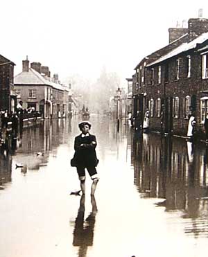
In the distant past when people selected a suitable place to settle, proximity to water was a major consideration. Newport Pagnell has two rivers, the Ouse and the Lovat (or Ouzel). And while they provided a ready supply of drinking water to the earliest residents, and a natural fortification barrier (except in the 900's when the Danes ransacked the town by rowing up the river from Bedford!), it does mean that the town is at risk from flooding. Residents of Newport Pagnell are not surprised to see Riverside meadows under water during the winter months, or to find Riverside Walk awash and impassable. But every few years the town suffers badly: the most recent being Easter 1998.
1939 was also a bad year, when heavy rain caused the Grand Union Canal to burst its banks at Great Linford, gushing water into the town. Older residents remember collecting coke in Caldecotte Street as it was washed down the road from the railway station. At the height of the flood there were cattle, sheep and hencoops coming under the Iron Bridge and down towards Sherington. |
|