|
 |
 |
 |
 |
 |
 |
 |
 |
 |
 |
 |
 |
 |
 |
 |
 |
 |
 |
 |
 |
|
|
|
|
|
|
|
|
|
|
|
|
|
|
|
|
|
|
|
 |
|
|
|
|
|
|
|
|
|
|
|
|
|
 |
 |
|
|
|
|
|
|
|
|
 |
|
|
|
 |
|
|
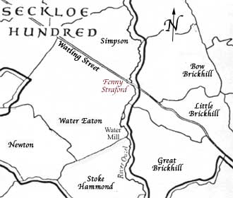
Post-Roman Watling Street maintained importance both as a road and as a natural boundary for land division, and with the creation of parishes in Anglo Saxon England, formed an ideal parish boundary along with the Ouzel and other local land features. To it’s north lay Simpson Parish and to its south the parish of Water Eaton with its water mill on the Ouzel, of which Fenny Stratford was a part. |
|
|
 |
|
 |
|
|
|
|
|
|
|
|
|
 |
|
Position of Fenny Stratford within the Anglo Saxon parishes, illustrating the use of river and road as boundaries.The north side of Watling Street being in Simpson and the south in Water Eaton. |
|
 |
|
 |
|
 |
|
|
The Norman Conquest of 1066 led to William I rewarding those knights and bishops who had supported his campaign. The parishes of Water Eaton and Fenny Stratford were given in 1075 to Geoffrey, Bishop of Coutances, who then lost them through disloyalty to the throne. The manor of Water Eaton was then in the hands of the distinguished Giffard family who had been staunch supporters of William I. Continue.. |
|
|
|
 |
|
|
|
 |
|
|
|
History |
|
The Timberyard |
|
Fenny Station |
|
Fenny Lock |
|
St Martins |
|
|
|
|


